Showing 110 items matching scales john
-
 Glen Eira Historical Society
Document - Bakewell Family
... Scales John... Derbyshire Howitt Godfrey Scales John Exeter College Oxford Downing ...There are 3 items about this family of early European settlers in Victoria: 1/A photocopy of an extract “Early Pioneer Families of Victoria and Riverina” – Henderson Page 441-442 The Bakewell Family of Burnewang and Tooradin”. It includes a photo of John Bakewell (1807-1888). It contains two pages and describes Bakewell’s property expansion. 2/An original copy of handwritten, unsigned undated research notes on John Bakewell property holdings taken from St Kilda Rate Book (1859-1873). It describes the land allotment. 3/A typed, unsigned, undated extract from 'The Howitts in Australia by Mary Howitt' - Mary Howitt, Vic Hist Mag 1913 Vol 3 No. 1. Reference – Memoirs of a Stockman, Harry Peck, 1853 Map, Foot Plot CCXLVI at Kooyong & Glen Eira Road. It provides a brief outline of the lives of brothers Robert and John Bakewell.the bakewell family, early pioneer families, henderson, bakewell john, port phillip, burnewang, bakewell robert, howitt godfrey dr, lord goderich, tooradin, phoebe, friends' school ackworth, yorkshire, nottingham, shaw john wyberg, plenty river, businesses, goldsbrough richard, goldsbrough mort and company ltd., glaziers, squatters, burnewang, mantons, tooradin, red bluff, torbinurruck, great swamp, brenanah, westernport, numerella, snowy river, orbost, green hills b, caramut, lyall william, mickle john, buckland john, notts, england, balderton, weddings, jane emily, howitt emanuel, farnsfield, lever mary, howitt thomas, heanor, derbyshire, howitt godfrey, scales john, exeter college oxford, downing college cambridge, guerard von, wayne john, south warnborough manor, harrison robert, lord john, jamaica, mary alice, dr. miller, miller john francis compton, emmie joan, mary emily, clifton hotel welbeck street, phoebe alice, anne edith, british museum, land values, settlements, st. kilda, elsternwick, inkerman street, st. kilda east, kew, memoirs of a stockman, harry peck -
 City of Moorabbin Historical Society (Operating the Box Cottage Museum)
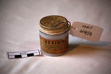
Manufactured Glass, jar 'Resinol' ointment, mid 20th C
Resinol is used to treat several different types of skin ailments. Resinol was developed by Dr. Merville Hamilton Carter (1857-1939) in his private practice as treatment for his patients in Baltimore, Maryland during the late 19th century. In 1895, Carter, along with his brother Allan L. Carter and his cousin Henry Stier Dulaney founded the Resinol Chemical Company and began to mass-produce the ointment and other medical products. After over forty years of selling Resinol, the company had John H. Buffham & Co. as an outlet in Great Britain and was a successful global distributor. Henry LeRoy Carter Sr., the son of Dr. Carter, began running the company after the deaths of his father and other staff members. The company's sales began to decline in the 1940s, and after the death of Henry LeRoy Carter Sr. in 1951, his son Henry LeRoy Carter Jr. took the place of his father and grandfather as president of the Resinol Chemical Company. At that time, the company focused more on soap manufacturing, but continued to sell Resinol. For the rest of the 20th century, Resinol's popularity continued to dwindle. It was purchased by ResiCal Inc. in 2002.A clear glass jar with a metal screw top containing 'Resinol' antipruritic and sedative ointment. Lid : ‘RESINOL’ / ( Ungt Resinol) / ANTIPURITIC AND / LOCAL SEDATIVE / A Soothing Preparation THAT PROMOTES HEALING/ OF SKIN IRRITATIONS/ Prepared Only By/ RESINOL CHEMICAL CO. / BALTIMORE MO / USA.. Jar : THIS IS REAL RESINOL/ Beware of substitutions……….. / RESINOL/ For relief of Itching, Chafing, Dandruff Scales, /…………/ Chemically Pure………….pharmacy, medicines, thars ointment, thar chemical company, hospitals, nursing, containers, moorabbin, bentleigh, cheltenham, melbourne, baltimore usa, resinol chemical company, skin diseases, maryland usa, carter merville hamilton, buffham company england -
 Ballan Shire Historical Society
Map - Map. Bullarook State Forest, Bullarook State Forest Reserve
A small map of the Bullarook State Forest Reserve. Drawn on a fine buff coloured paper attached to a stiff cloth backing sheet. The title is hand written and includes a "scale one mile to one inch" hand written also. The map is signed "John Wrigglesworth, assistant ? and dated 26/6/1869" although the month and year are almost illegible.moorabool west, state forest, bullarook, eastern moorabool river, werribee river, moorabool east, blakes saw mill, wombat, andersons saw mill -
 Ballan Shire Historical Society
Map - Map. Moorarbool East and West, Country Lands in the Parishes of Moorarbool East and Moorarbool West. Counties of Bourke and Grant
This is a map of "Country Lands" around the Werribee River, north of Ballan in the Counties of Bourke and Grant.A relatively small map, paper on a material backing. Shows topographical features, roads and property divisions. Scale of forty chains to one inch. The map is dated March 31st, 1859.There is a small inscription under the chain scale that reads "No 58/364 John Phillips ? Survey 1st August 1858". The name Dugald McPherson is hand written on one of the blocks of land.moorarbool west, moorarbool east, dugald mcpherson, county of bourke, county of grant, werribee river, ballan -
 Phillip Island and District Historical Society Inc.
Photograph, Bryant West
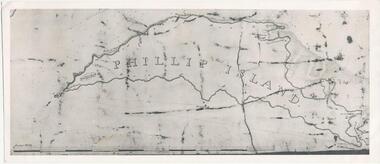
One of a collection of over 400 photographs in an album commenced in 1960 and presented to the Phillip Island & Westernport Historical Society by the Shire of Phillip IslandPhotograph of an early Map of Phillip Island not drawn to scale. Copy from Records Office, London.On back of photo - "If used must bear acknowedgement - reproduced by permission of the Hydrographer of the Navy" "Received 18/3/1955 from London Records Office per Mr mcGrigor-Phillips" Printed on Map "Phillip Island"local history, photography, photographs, maritime documents, maps, exploration, john jenner, bryant west, phillip island map -
 Federation University Historical Collection
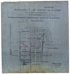
Plan, Plan applied for a Lease, Parishes of Glenmora and Rothcar, 27/05/1913
Plan on linen showing mining leases around the township of Lower Homebush, District of Maryborough. Scale: 20 chains to in inch (1:15840) WGS 84 Centroid Lat: 37 degrees 01 feet 35 inches S Long: 143 degrees 30 feet 35 inches S NS: 3.2km EW: 2.8km glenmona, rathcar, gladstone, maryborough, mining, clarence smith, homebush, clarence smith, w d thompson, peter leyden, b elliot, c horne, a field, john leydon, g jolly, r e jolly, d garner, s j barry, m harris, a harris, w j mcconnell, ellen harris, r j harris, j barry, t curtain, s garner, e barry, m j barry, l e squires, wilkins jnr, e c grace, e j field, mary field, m broughton, b l lusby, m j lusby, j e field, f broughton, j gillock, m simmons, glenmona, rathscar, parish of avoca, maryborough district, albert field, g grose, j harris -
 Federation University Historical Collection
Photograph - Photographs - colour, VIOSH: Postgraduate Student, Geoffrey Dell's PhD, 1996, c1996
Victorian Institute of Occupational Safety and Health (VIOSH) Australia is the Asia-Pacific centre for teaching and research in occupational health and safety (OHS) and is known as one of Australia's leaders on the field. VIOSH has a global reputation for its innovative approach within the field of OHS management. VIOSH Australia enrolled its first PhD candidate in 1995 and during 1996 focused on attracting increasing numbers of students. In 1996, three candidates were enrolled through VIOSH Australia.They were John Culvenor, Geoffrey Dell and Thomas Mitchell. All had Prof Dennis Else as their supervisor. Previously, Geoffrey Dell was in Intake 7, 1985, Occupational Hazard Management. Geoffrey Dell's topic was "Airline Baggage Handler Back Injuries - Causes and Prevention." "The aim of this study is to investigate the work practises and operational systems used by baggage handlers in a range of airlines, worldwide. Where possible the investigation will include an epidemiological study of baggage handler back injury occurrence in those airlines. The information gathered will provide an understanding of back injury causation modes, and will focus attention on the specific tasks for which engineering solutions should be sought. Engineering solutions identified will be subject to controlled trial, to confirm their validity." This led to the construction of a full scale plywood baggage compartment model and a partnership with Ballarat University's School of Human Movement and Sports Science. Three different loading systems were tested. Qantas baggage handlers travelled to Ballarat University to fill the human frame of the investigation. The photographs show this aspect of the research. In 1997, Geoffrey Dell was awarded the Eric Wigglesworth Prize. The prize acknowledges publication of an article which constitutes a significant contribution to the body of occupational health and safety knowledge in an approved OH&S journal.32 co;our photographs showing procedure of baggage handlers.viosh, victorian institute of occupational safety and health, geoffrey dell, john culvenor, thomas mitchell, phd, airline baggage handler back injuries, work practises, operational systems, engineering solutions, causes of injury, qantas baggage handlers, prof dennis else, eric wiggles worth prize, oh&s journal, ballarate university, school of human movement and sports science, plywood compartment model, loading systems -
 Federation University Historical Collection
Booklet - Annual Report, The Ballarat School of Mines, Industries and Science, Annual Report 1891, 1891
The Ballarat School of Mines Annual Report 1891. Annual Report, Crown Grant, Affiliation Statute, Constitution, Examination Statutes, Associateship of The School, Certificates Granted by the Council, Clunes Branch Report, Departmental Expenditure, Fees, Form of Bequest, Gauge-Testing Apparatus, General Balance Sheet and Liabilities and Assets, Honorary Correspondents, Life Governors, Meteorological Observations, Number of Students attended The School of Mines, Office Bearers, Practical Treatment of Ores, Report of the Professor of Mineralogy and Geology and Curator of the Museum, Report of the Superintendent of Laboratories, Report of the Lecturer on Engineering and Surveying, Report of the Lecturer on Mathematics, Report of the Lecturer on Electrical Engineering and Telegraphy, Report of the Lecturer on Botany, Report of the Lecturer on Geometrical and Freehand Drawing, Report of the Lecturer on Materia Medica and Physiology, Report of University Classes, Report on Mining Laboratory, Examinations Held, Scale of Charges for Assays and Analyses, Statement of Receipts and Expenditure for the year 1891 and Special Trust Funds, Statistics - Students attending Lectures, Subjects and Lecturers, Subjects and Examiners, Subscriptions and Donations from 1st January to 31st December 1891, Syllabus of Lecture CoursesThe Ballarat School of Mines Industries and Science Annual Report, 1891. Cover is browning around the edges, front cover has small tear on bottom of cover, 132 pages. ballarat school of mines, annual report, andrew anderson j.p. - president, f. j. martell - vice president, r. denham pinnock - vice president, rivett henry bland - trustee, the hon. sir w. j. clarke - trustee, the hon. john warrington rogers - trustee, james oddie - trustee, the hon. henry cuthbert - honorary solicitor, c. eyres - honorary treasurer, charles kent - auditor, andrew berry - registrar, f. m. krause - professor of mineralogy and geology, and curator of the museum, alf. mica. smith - chemistry, metallurgy, natural philosophy, f. m. krause - geology, mineralogy, geological surveying, j. h. horwood - lecturer on engineering and surveying, h. j. hall - lecturer free-hand and model drawing, george day - botany, j. f. usher - materia medica and physiology, c. w. wilson - university classes, isaac jaques jones j.p., mr e. wattis - manager, mining laboratory, j. a. dawson - electrical engineering and telegraphy, elder gray, harry e. sando, charles matthews - auditor, j. h. daley - auditor, henry crone - assistant registrar of titles, henry b. loch, isaac jacques jones, charles eyres, j.a, j.a. dawson, statistics, university classes, bella guerin, c.w. wilson, clunes branch of the ballarat school of mines, w.e. burbridge, h.j. hall, museum, state school students, daniel walker, a.j. higgins, state school science classes -
 Federation University Historical Collection
Booklet, The Ballarat School of Mines, Industries and Science, Calendar and Annual Report 1893, 1893
The Ballarat School of Mines Annual Report 1893. Annual Report, Examination Papers, Associateship of The School of Mines, Syllabus for Technical Schools, Crown Grant, Affiliation Statute, Certificates Granted by the Council, Clunes Branch Report, Departmental Expenditure, Fees, Form of Bequest, General Balance Sheet and Liabilities and Assets, Honorary Correspondents, Life Governors, Meteorological Observations, Number of Students attended The School of Mines, Office Bearers, Practical Treatment of Ores, Report of the Professor of Mineralogy and Geology and Curator of the Museum, Report of the Superintendent of Laboratories, Report of the Lecturer on Engineering and Surveying, Report of the Lecturer on Mathematics, Report of the Lecturer in Mechanical Drawing, Machine Construction and Design, Report of the Lecturer on Electrical Engineering and Telegraphy, Report of the Lecturer on Botany, Report of the Lecturer on Biology, Pharmacy, Materia Medica, Report on Mining Laboratory, Examinations Held, Scale of Charges for Assays and Analyses, Statement of Receipts and Expenditure for the year 1892 and Special Trust Funds, Statistics - Students attending Lectures, Subjects and Lecturers, Subjects and Examiners, Subscriptions and Donations from 1st January to 31st December 1892, Syllabus of Lecture Courses6188: The Ballarat School of Mines Industries and Science Calendar and Annual Report, 1893. Red soft cover is browning around the edges, spine is tattered, 156 pages. 6188.2: Red soft covered booklet of 26 pages, Office Copyballarat school of mines, annual report, andrew anderson j.p. - president, f. j. martell - vice president, r. denham pinnock - vice president, rivett henry bland - trustee, the hon. sir w. j. clarke - trustee, the hon. john warrington rogers - trustee, james oddie - trustee, the hon. henry cuthbert - honorary solicitor, r. g. middleton - honorary treasurer, charles kent - auditor, andrew berry - registrar, alf. mica. smith - chemistry, metallurgy, f. m. krause - geology, mineralogy, mining, j. h. horwood - mechanical engineering, machine drawing and design, theoretica and applied mechanics, mathematics, henry j. hall - freehand and model drawing, j. a. dawson - electricity and magnetism, george day - botany, e. gutheil - biology, materia medica, pharmacy, a. e. c. kerr - mechanical drawing, machine construction and design, e. gutheil - biology, pharmacy, materia medica, henry crone - assistant registrar of titles, henry b. loch, elder gray - president, clunes branch, harry e. sando - registrar, clunes branch, w. y. witherden - hon. treasurer, clunes branch -
 Federation University Historical Collection
Slide, Welcome Stranger Monument, c1970
The first recorded discovery of gold in Moliagul was in September 1852 and, before long, the area was flooded with over 4,000 miners. Two of those miners, John Deason and Richard Oates, had arrived in Bendigo in 1954 seeking their fortune. After eight years of little success, the friends moved to Moliagul and pegged a puddling claim. On 05 February 1869, Deason discovered a nugget near the roots of a tree, just 3cm beneath the soil. With the help of Oates, he uncovered the largest recorded alluvial gold nugget – known as the Welcome Stranger. The 61cm x 31cm nugget was taken to Dunolly to be measured on the bank’s scales, however at 69kg the gold needed to be broken on an anvil to actually fit on the scales.Photograph of the monument for the Welcome Nugget, a large gold nugget found by John Deason and Richard Oates at Moliagul.Obelisk inscription Welcome Stranger Nugget On this spot the largest nugget of gold in the world was discovered on the 5th February 1869 by John Deason and Richard Oates. Weight 2316 oz, Value £9553 Erected by the Mines Department 1897 Henry Foster Minister of Mines, D. J. Duggan M.L.A. Member for Dunollywelcome nugget, welcome nugget monument, john deason, richard oates -
 Federation University Historical Collection
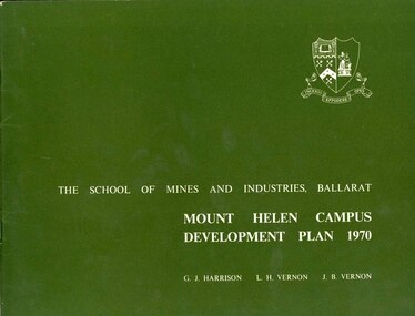
Book, Mount Helen campus Development Plan 1970, 1970
Green and white soft covered booklet of 48 pages. SMB Crest is on the front cover. The content include the Mt Helen site, site planning, student residences, sporting facilities, roads and parking, pedestrian circulation, engineering services, and landscaping. Illustrations include: Plan of Mt Helen Site (July 1969, existing buildings, Functional relationship, Roads and Parking, Pedestrian Circulation, engineering Services, Landscaping, Development Plan, Plan of Academic area, Library and union Courtyards, Birds Eye View of Academic Area from north-west, etc. the master plan projects student numbers.non-fictionuniversity of ballarat, ballarat institute of advanced education, mount helen, master plan, landscape, harrison, vernon, great hall, geoff harrison, john vernon, m.b. john, contour map, student accomodation, landscaping, development plan, campus plan -
 Flagstaff Hill Maritime Museum and Village
Instrument - Spring Scale
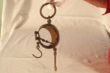
The first spring balance in Britain was made around 1770 by Richard Salter of Bilston, near Wolverhampton. He and his nephews John & George, founded the firm of George Salter & Co., still notable makers of scales and balances, who in 1838 patented the spring balance. They also applied the same spring balance principle to steam locomotive safety valves, replacing the earlier deadweight valves. https://en.wikipedia.org/wiki/Spring_scale Today, spring scales are very popular with recreational fishers. The ability to weigh things reasonably accurately with a small inexpensive apparatus allowed for the exact weight of items to be ascertained. However, it was not accurate enough to weigh small amounts in ounces or grams.Scale. Has ring for hanging, spring and hook device for weighing. Measures in lbs.Scale of pounds weight.flagstaff hill, warrnambool, shipwrecked-coast, flagstaff-hill, flagstaff-hill-maritime-museum, maritime-museum, shipwreck-coast, flagstaff-hill-maritime-village -
 Flagstaff Hill Maritime Museum and Village
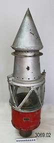
Functional object - Marine Navigation Light, Early 20th century
Breakwater navigation lights are placed at the end of the breakwaters to warn incoming vessels of the end of the structure, as a marine safety measure. The subject item was such a light believed to have been placed at the end of Warrnambool's breakwater around 1915 when it was extended. The light had remained in place for many years until it was probably removed when the structure was undergoing rock armouring repairs to the end of the breakwater in 1975. The light had been placed in a council storage shed probably from the time when the structure was undergoing these repairs in 1975. In 2014 the light was removed from the storage shed and donated to Flagstaff Hill museum. History: Warrnambool breakwater plans were drawn up by 1874 and approval was given for preliminary construction work to start but when the money ran out, the works stopped. With a number of quick changes of government the “Warrnambool” breakwater project was kicked from one Victorian state government to another. Then finally in 1879, the eminent British harbour engineer Sir John Coode was asked to design a breakwater. His first design was for a 1800 feet long structure but that was scaled back to 900 feet and construction finally began in 1884. This structure was attributed in causing major siltation of Lady bay, as a consequence the breakwater was again extended in 1915. In 1975, the rock armouring at the end of the breakwater was added but by 1979 another impact study was calling for the breakwater to be removed altogether. The Heritage Council Victoria, regard the Warrnambool breakwater is of historical significance to the state as one of the most important maritime engineering projects that was undertaken in Victoria during the late nineteenth century. The light is also as part of this structure regarded as a significant item of historical interest.Marker light or navigation light. Round light stand with conical top piece (2 separate pieces). Metal base painted red, clear glass middle section enclosed by metal frame, metal cone shaped top section painted silver. Electrical wiring can be seen inside centre section. Pole that light would have been on to elevate it is missing.Has metal plate screwed onto side of base engraved "23". flagstaff hill, warrnambool, shipreck coast, flagstaff hill maritime museum, maritime museum, great ocean road, warrnambool breakwater, marker light, naviagtion light, breakwater navigation light -
 Flagstaff Hill Maritime Museum and Village
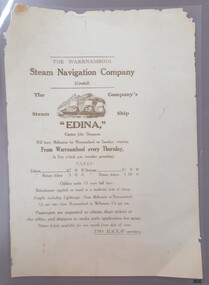
Document - Poster, Warrnambool Steam Navigation Co, ca.1938
This poster is typical of posters displayed by steam packet companies of the mid-19th to early 20th centuries. It advertises the passage and freight available on a local coastal trader. The steamships operated between the major ports along the western coast of Victoria between Melbourne and Portland. The traveller was not guaranteed the passage times due to possible weather changes. Discounts were offered for return trips within a month of the ticket's issue. The price of freight included 'lighterage', which was the service of a smaller vessel called a 'lighter' expressly designed to transport goods between ship and shore. This particular poster advertises the services of the screw steamer SS Edina. The information on the poster applies to the years between 1871 and 1873. During that period the Master of the Edina was Captain John Thompson, the Edina was owned by the Warrnambool Steam Navigation Company and the secretary of the firm was Thos. Mackay. The passenger fares are in line with fares from that period, as seen in a display advertisement published in the Hamilton Spectator on January 17th, 1872. The 1853 Glasgow-built Screw Ship Edina had a long life. The ship served in both the Crimean War and the American Civil War. The Edina also traded in UK and European waters. The Henty family of Portland, Victoria, purchased Edina in 1863 for use as a coastal trader. The Edina had several owners and spent many years of service along the South West Coast of Victoria between Melbourne and Portland. The vessel transported passengers and freight in Port Phillip Bay, between Melbourne and Geelong, between 1880 and 1938. After 84 years of service, the Edina was renamed ‘Dinah’ and was stripped down for use as a lighter. The vessel was broken up in 1957 at Footscray, Melbourne. The remains of Edina’s hull can be found in the Maribyrnong River, Port Phillip Bay. The poster was owned by the donor's grandfather, Bruce Duff (1922-2003) who was an avid sailor and a lover of nautical history. He and his wife Mona (1924-2014) were buried in Portarlington Cemetery, Victoria. Duff would have been about 13 years old when the Edina was finally retired from service in 1938. His interest in the Edina could have come from a trip on the vessel or from watching it in operation in the ports along the coast. Duff has collected this poster as a memento of the Edina and is likely to have preserved it at a much later date when the lamination process was readily available. [Flagstaff Hill's collection includes a photograph of the Edina at the Moorabool Street Wharf, Geelong, which was in Duff's locality. The References for this poster include a link to Museum Victoria's photograph of two boys watching the Edina from a jetty.] Flagstaff Hill's Village has its own 'Examiner' Office where volunteers demonstrate the historic printing press in that building. They use original letter-type to create posters, print labels onto lolly bags and designs on fabrics. One of the volunteer printers has produced a poster closely resembling the donated poster. His replication includes a woodcut of the ship, which he skilfully crafted himself.This poster advertises the sailing of the steamer SS Edina and the information has local and State significance for its association with the trading ports of the Edina, and the associated names on the poster; Warrnambool Steam Navigation Company, Captain John Thompson and Thos. Mackay. This poster's message has a strong connection to the history of the businesses and community of Warrnambool and the people of Port Phillip Bay, where it was a passenger ferry for many years. The poster is an example of advertising used by shipping agents in the mid-19th to early 20th centuries. Its information includes the accurate costs to passengers and freighters and the type of timetable the vessels were likely to follow. The poster's connection with the Screw Steamship Edina is historically significant, as the vessel was the longest serving screw steamer in the world. The ship spent its first nine years overseas then arrived in Melbourne. The vessel's work included running the essential service of transporting cargo and passengers between Melbourne and the western Victoria ports of Warrnambool, Port Fairy and Portland. The Edina is listed on the Victorian Heritage Database VHR S199. Poster, A3 size, brown text on cream paper, laminated. Poster of the Warrnambool Steam Navigation Company (Limited) advertising passage and freight on its Screw Steamship, SS Edina. It states days, times and fees for passage and freight from Warrnambool to Melbourne, and return. It names the ship's Master, Captain John Thompson and the Company's Secretary, Tho. Mackay. It displays a line drawing of a 3-masted ship with full sails.Printed image [side profile of a 3 masted vessel, bow facing left] Printed text includes "The Warrnambool Steam Navigation Company (Limited). The Company's Steam Ship "EDINA", Captain John Thompson, Will leave Melbourne for Warrnambool on Tuesdays, returning from Warrnambool every Thursday, At Five o'clock p.m. (weather permitting). FARES: Saloon £2 0 0 Steerage £1 0 0 Saloon return £3 0 0 Saloon return £1 10 00 - Children under 13 years half fares - Refreshments supplied onboard at a moderate scale of charge. Freight, including lighterage, - From Melbourne to Warrnambool - 12s per ton; from Warrnambool to Melbourne, 15s per ton. Passengers are requested to obtain their tickets at the offers, and shippers to make early application for space. Return tickets available for one month from date of issue. - THO. MACKAY, secretary. "warrnambool, shipwreck coast, flagstaff hill, flagstaff hill maritime museum, maritime museum, fair maid of judea, steam navigation, pleasure steamer, ss edina a, trade 19th century, travel 19th century, warrnambool to melbourne, warrnambool to geelong, warrnambool to port fairy, warrnambool to portland, screw steamer, coastal trader, crimean war, american civil war, gold export, h r h duke of edinburgh, warrnambool steam packet company, stephen henty, captain john thompson, chief engineer john davies, lady bay, lighter edina, port phillip bay steamers, vhr s199, dinah, warrnambool steam navigation company, advertising poster, shipping agent, flier, maritime village, flagstaff hill maritime museum & village, great ocean road, block printing, woodblock printing, relief printing, moorabool st wharf, western steam navigation company, tho. mackay -
 Flagstaff Hill Maritime Museum and Village
Container - Ink Bottle, Second half of 19th Century or first half of the 20th Century
Although glass containers for wine and beer are probably 1,600 years old, much of their use began only in the late 17th century. In the United States, large-scale production of bottles was pioneered by Caspar Wistar in 1739 at his New Jersey plant. In the 1770s the carbonation process for producing soft drinks was developed, and so began an entirely new bottling industry. At the Great Exhibition of 1851 in the Crystal Palace in London, one million “pop” bottles were consumed. The first beer pasteurised in glass was produced in Copenhagen in 1870. Pasteurisation of milk followed soon after. The moulding of a screw thread on a container was invented by John Mason in 1858. The principles of the “press-and-blow” process for making wide-mouth jars were shown in the United States by Philip Arbogast in 1882, and the “blow-and-blow” process for making narrow-neck containers was demonstrated by Howard Ashley in England in 1885. These processes employed manual delivery; fully automatic jar forming by a suction-and-blow process was perfected by Michael Owens over the period 1895–1917 at the Toledo (Ohio) Glass Company, which subsequently became the Owens Bottle Machine Company. The automatic single-gob feeder was developed in 1919–22 by Karl Peiler at the Hartford-Fairmont Company in Connecticut. Fully automatic machines followed, but the true rugged survivor, utilising fully automatic gob delivery to the maximum versatility, was the Individual Section, or IS, machine invented by Henry Ingle at the Hartford Empire Company in 1925. Source: https://www.britannica.com/topic/glass-properties-composition-and-industrial-production-234890/History-of-glassmakingUnlike item 4018, this is a much smaller ink bottle, and was probably used by an individual, as against the supply of ink to pupils from a much larger bottle.Cotton Reel Ink Bottle, green glass, small, chipped around the lip, bubbles in glass.None.flagstaff hill, warrnambool, shipwrecked-coast, flagstaff-hill, flagstaff-hill-maritime-museum, maritime-museum, shipwreck-coast, flagstaff-hill-maritime-village, ink, bottle, glass -
 Bendigo Military Museum
photograph - Cartographic Squadron Production – Army Survey Regiment, Fortuna, c1980
This collection of 12 photos was most likely taken in 1980. The photos were most likely taken in Cartographic Squadron’s Ante Room, the Attic and small offices on the top floor of Fortuna Villa. The computer based Editwriter typesetting system was introduced in 1975 as a replacement to the aging Fotosetter machine. It was operated by a specialised technician, who generated a large variety of map type styles and sizes quickly and reliably, as well as text panels. CPL Richards performed this task for several years and in photo .1P and .2P is reading off a type order next to the computer monitor. Output on Copy proof adhesive backed stripping type film replaced messy wax and spray adhesives in 1978. The Editwriter capability supported all RASvy units and contractor type setting requirements. Scribing was the cartographic process of drafting features such as drainage, relief, vegetation, roads and culture on specially coated map reproduction material. The cartographic technician scribed out the map feature such as a contour to a specified line width on the map sheet, using a tool affixed with a sapphire tipped cutter. The quality control edit (Proving) stage of map production was the first opportunity to inspect a proof of the map independently and systematically. Proving tasks were carried out by technicians conversant of the map product specification and task requirement, however, was not involved in its production. Corrections were identified, marked up and sent to back to the correcting section or contractors. Terrain Embossing was a manual map production technique to produce hill shading on medium to small scale graphics and air charts. SPR John Martin is seen in photos .8P to.10P using a fine embossing metal stylus to push down on the drainage impression on a thin malleable opaque plastic material (AK Poligraphy). Ridge lines were then pushed down using the contour impression as a guide, on the opposing side of the AK Poligraphy to create a 3D plastic model terrain effect. The map impression was sprayed with white paint and photographed to create a contone tone hill shade. SPR Gina (Coore) Neilson is seen in photo .11P washing a contone positive of a land mass in a solution. The contone components were registered to the map sheet, as shown in photo .12P and masked using an air brush and a halftone negative was then created. The terrain embossing method of producing hill shading was more efficient to produce than previous specialised artistic methods such pencil/eraser and air brush. Furthermore, a more consistent enhancement of terrain on charts was achieved between technicians.This is a set of 12 photographs of Cartographic Squadron performing four map production tasks at the Army Survey Regiment, Fortuna, Bendigo c1980. The first ten photographs were on 35mm negative film and were scanned at 96 dpi. Photos .11P and .12P were on photographic paper and scanned at 300 dpi. They are part of the Army Survey Regiment’s Collection. .1) - Photo, black & white, c1980, Editwriter typesetter, CPL Paul Richards. .2) - Photo, black & white, c1980, Editwriter typesetter, CPL Paul Richards. .3) - Photo, black & white, c1980, Scribing contours on a RAAF Chart, SPR Megan (McBurney) Reynolds. .4) - Photo, black & white, c1980, Scribing contours on a RAAF Chart, SPR Megan (McBurney) Reynolds. .5) - Photo, black & white, c1980, Scribing contours on a RAAF Chart, SPR Rod Skidmore. .6) - Photo, black & white, c1980, Scribing contours on a RAAF Chart, SPR Rod Skidmore. .7) - Photo, black & white, c1980, Formal quality control edit (Proving), CPL Ian Belmont. .8) - Photo, black & white, c1980, Hill Shade Terrain Embossing, SPR John Martin. .9) - Photo, black & white, c1980, Hill Shade Terrain Embossing, SPR John Martin. .10) - Photo, black & white, c1980, Hill Shade Terrain Embossing, SPR John Martin. .11) - Photo, black & white, c1980, Hill Shade Terrain Embossing, SPR Gina (Coore) Neilson. .12) - Photo, black & white, c1980, Hill Shade Terrain Embossing, unidentified..1P to .10P No personnel are identified. .11P and .12P annotated ‘Terrain Embossing’royal australian survey corps, rasvy, army survey regiment, army svy regt, fortuna, asr, carto -
 Bendigo Military Museum
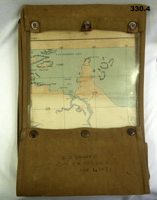
Accessory - MAP CASE & MAPS, C.1939 -45
John James Davies No VX35280 enlisted in the 2nd AIF on 1.8.40 age 31 years. At discharge on 30.11.45 he held the rank of WO 2nd class in 2/108th Aust Light Anti Aircraft detachment..1) Map case, canvas khaki. .2) Map of Darwin, NT. Scale 4 miles to 1 inch. .3) Map, folded, New Guinea made by Hec Robinson Sydney .4) Map Pine Creek N.T.zippered section marked "J. J. Davies VX35280 108 LAD”maps, canvas case, military -
 Bendigo Military Museum
Photograph - Johnson Ground Elevation Meter (JGEM) Survey Vehicle - Army Survey Regiment, Fortuna, Bendigo, c1960s
This is a set of 16 photograph of the Royal Australian Survey Corps’ Johnson Ground Elevation Meter (JGEM) Survey Vehicle taken at the Army Survey Regiment, Fortuna, Bendigo. The JGEM vehicle was extensively used by RA Svy within Australia from the late 1960s. A limited number of Ground Elevation Meter (GEM) station wagon type vehicles were manufactured by General Motors Corporation (GMC) in the USA for the United States Geological Survey, Canada’s mapping agencies, RA Svy and National Mapping (Natmap). The GEM was a four-wheel drive, four-wheel steer vehicle. Four-wheel steering was necessary to avoid systematic errors caused by non-tracking of front and rear wheels on conventionally steered vehicles. The manufacturer substituted the rear axle with a front axle and connected them to form the four-wheel steering mechanism. The two Australian GEM vehicles, referred to as Johnson GEMs (JGEMs) were converted into right-hand drive. After delivery in 1964, acceptance Natmap and RA Svy testing and operator training was undertaken at the Army's School of Military Survey located at Balcombe, Victoria. A small fifth wheel was mounted on a cantilever arm suspension midway between the front and rear wheels on the right side of the vehicle. It was lowered to and raised from its operating position by use of a constant pressure air cylinder. A telescopic bar, suspended between the front and rear axles, provided the reference datum for the angle measurement. The wheel provided the velocity or distance signal through a pulse generator system. A sensitive pendulum mounted on this bar provided the angle measurement for each minute distance traversed. The JGEM contained electromechanical instruments used to determine relative elevations, by trigonometric principles, along a traversed path. These relative elevations were obtained through apparatus which measures the instantaneous angle of inclination of the road and the instantaneous velocity of the meter along such a path. Road routes over which the JGEM operated were planned so that each started and ended as near as practicable to an existing point of known elevation (formally referred to as a level traverse bench mark). The difference in height from the bench mark and the road surface alongside the JGEM’s fifth wheel was measured with a level and staff. Along each route, mapping control photo reference points where new elevation values were required were identified on aerial photographs. Under favourable conditions it was possible to survey as much as 160km in an ordinary working day. The first of RA Svy’s JGEM operations was undertaken in 1:250,000 scale map areas of Queensland. CPL John Hook was the JGEM’s main operator in the early 1970s undertaking operations covering 1:250,000 scale map blocks over northern Victoria and central NSW, each requiring 36 points (9 runs of photography and 4 points across. SPR Lyn Thompson and SPR Bob McDonagh teamed with CPL Hook on some of these JGEM operations. When RA Svy was integrated into the Royal Australian Engineers in 1996, the JGEM vehicle with the Survey Corps collection was donated to its museum. It is believed to be the last of the original manufactured fleet in existence. The JGEM has undergone extensive refurbishment to achieve roadworthiness and is currently housed at The Australian Army Museum of Military Engineering, Hoslworthy Barracks, NSW. It can be viewed by making an appointment with the museum’s curator.This is a set of 16 photograph of the Royal Australian Survey Corps’ Johnson Ground Elevation Meter (JGEM) Survey Vehicle taken at the Army Survey Regiment, Fortuna, Bendigo. The photographs were on 35mm slide film and were scanned at 96 dpi. They are part of the Army Survey Regiment’s Collection. .1) - Photo, colour, c1960s, Johnson Ground Elevation Meter (JGEM) Survey Vehicle .2) - Photo, colour, c1960s, JGEM instrumentation, on-board computer. .3) - Photo, colour, c1960s, JGEM instrumentation. .4) - Photo, colour, c1960s, JGEM instrumentation, on-board computer. .5) - Photo, colour, c1960s, JGEM tyre pressure controller .6) - Photo, colour, c1960s, JGEM rear doors, SGT Geoff Briggs. .7) - Photo, colour, c1960s, JGEM 5th wheel distance/angle measurement device in lowered position, SGT Geoff Briggs. .8) - Photo, colour, c1960s, JGEM 5th wheel distance/angle measurement device in lowered position. .9) & .10) - Photo, colour, c1960s, JGEM tyre pressure system, SGT Geoff Briggs. .11) - Photo, colour, c1960s, JGEM tyre pressure system. SGT Geoff Briggs. .12) - Photo, colour, c1960s, JGEM levelling scope, levelling staff, unidentified technicians. .13) & .14) - Photo, colour, c1960s, JGEM levelling scope, unidentified technician. .15) & .16) - Photo, colour, c1960s, probably survey operation adjusted height plotted on block base sheet. .1P to .16P - Some of the equipment is annotated on the frame of the 35mm slides.royal australian survey corps, rasvy, army survey regiment, army svy regt, fortuna, asr, surveying -
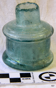
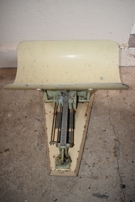
 Orbost & District Historical Society
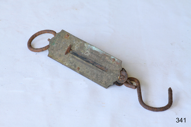
scales, late 19th - first half 20th century
William (Billie) Blackmore was born at or near Richmond, Victoria.At age 26 he joined the A.I.F. in WW1 while he was employed at Orbost as a labourer. He served in Egypt and France until following his discharge on December 20th 1916, he transferred to 15th Machine Coy in January 1917. He was severely wounded, repatriated to England until after an operation and further hospitalisation returned home to Orbost .In Orbost he did farm work for George and Elizabeth Trewin, eventually building a small shack on what was Rupert Leatham's property at Brodribb. He fossicked for gold in a nearby creek and the story goes that he buried his coins around the property. He donated these scales to the Orbost & Districet Historical Society. (more details and ref. John Phillips July 2016 Newsletter)This item is typical of those used by gold fossickers in the early 20th century. This object was likely to have been imported into Australia (possibly German) for use in Victoria,Small round hanging scales. At the top is a loop for hanging. There is a brass plate in the centre with measuring scale, in lbs, and needle pointer.scales instruments-weighing -
 The Beechworth Burke Museum
Photograph, 1920-1950
This image taken between 1920-1930 depicts open-cut hydraulic sluicing at the Three Mile Mine, located about five kilometres south of Beechworth. Alluvial, or surface, mining began on this site in the 1850s, but was soon replaced by hydraulic sluicing methods. By the start of 1880 it is estimated that nine hundred miles of water races had been cut though soil and rock in the Beechworth district. Hydraulic sluicing employs high pressure jets of water to blast away large areas of earth and wash it down to be run through a sluice box. Gold gets caught in the sluice and the remaining slurry is washed away. Large water quantities were required for hydraulic sluicing, and the long water races and deep tailraces that were constructed were considered great engineering feats. This method of mining is extremely effective, but causes significant environmental damage and impacts to waterways and agricultural operations. Miners at Beechworth built extensive networks of races and dams to secure reliable supplies of water on a scale far greater than elsewhere in Victoria. By the 1880s Beechworth's water barons continued to hold more than half of all the water right licences on issue and undertook sluicing operations on a massive scale. The manipulation of surface and ground water via race networks was well planned and recorded in detail by local mining surveyors. The maps that were created, combined with modern geo-spatial technologies, provide a vital key in understanding the great lengths to which miners went to capture and control critical water resources. Today, Three Mile mine is called Baarmutha. The Three Mile Mine was unproductive until 1865 when John Pund and three other miners secured a fifteen year license and constructed a water race from Upper Nine Mile Creek to Three Mile Creek. In the early twentieth century Pund & Co. averaged over one thousand ounces of gold per year from the mine. After Pund's death in 1915, GSG Amalgamated Co operated the site, continuing sluicing until 1950. This image of hydraulic sluicing methods shows the extent of water-works engineering in the landscape. This photograph has historic and research potential for understanding changes to the landscape, the evolution of mining methods, and the extensive construction, manipulation and management of water networks in the Beechworth district. Black and white rectangular photograph on matte paperReverse: 7597-1 / Sluice Mining / Copied from original on loan from Webb (Qld) / Donated Nov 2009 / Baarmutha Three Mile Mine c1920-1950 / Managed by the Plain Bros then Parkinsons / Current Location is: Beechworth Animal Shelter / used for Baarmuthaburke museum, beechworth museum, beechworth, gold fields, gold rush, victorian gold rush, hydraulic sluicing, spring creek, netwown falls, mining tunnels, water races, tailraces, gold ming history, colonial australia, australian gold rushes, mining technology, beechworth historic district, indigo gold trail, indigo shire, john pund, water manipulation, water engineering, three mile creek, three mile mine, water race, large-scale mining methods, historical mining construction, alluvial mining, mining environmental impacts, baarmutha, water barons -
 The Beechworth Burke Museum
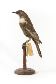
Animal specimen - Ring Ouzel, Trustees of the Australian Museum, 1860-1880
The Ring Ouzel is a member of the Thrush family, Turdis, of which there are about 85 different species, commonly located in Europe. They are found in upland Scotland, northern England, north west Wales and Dartmoor. This species is identified by their dark colouring which contrasts to the white crescent across the breast and the white edging on the wings and some body feathers which provides a scale-like appearance. The diet of this species consists of invertebrates, some small vertebrates and a wide range of fruit. This specimen is part of a collection of almost 200 animal specimens that were originally acquired as skins from various institutions across Australia, including the Australian Museum in Sydney and the National Museum of Victoria (known as Museums Victoria since 1983), as well as individuals such as amateur anthropologist Reynell Eveleigh Johns between 1860-1880. These skins were then mounted by members of the Burke Museum Committee and put-on display in the formal space of the Museum’s original exhibition hall where they continue to be on display. This display of taxidermy mounts initially served to instruct visitors to the Burke Museum of the natural world around them, today it serves as an insight into the collecting habits of the 19th century. This specimen is part of a significant and rare taxidermy mount collection in the Burke Museum. This collection is scientifically and culturally important for reminding us of how science continues to shape our understanding of the modern world. They demonstrate a capacity to hold evidence of how Australia’s fauna history existed in the past and are potentially important for future environmental research. This collection continues to be on display in the Museum and has become a key part to interpreting the collecting habits of the 19th century.The Ring Ouzel specimen is stylised perched on a wooden platform. It is a medium sized bird of the thrush family. This particular specimen is a brown colour with pale edging to the wing feathers rather than the plumage being a darker black which can help identify this bird as female. The feathers have a white edging on the stomach giving this bird a scaly appearance. The bird has a small dark bill, two glass eyes, black legs and a long tail. Around the front of the upper breast, the bird has a striking white crescent shaped band. "Label 1 110a. / Ring Thrush / Catalogue Page 29 / Lable 2 Furdus torquaters / [illegible] 10 OCT. 1859 / near Leiden /"taxidermy mount, taxidermy, animalia, burke museum, beechworth, australian museum, skin, reynell eveleigh johns, bird, european birds, ring ouzel, blackbird, ouzel -
 The Beechworth Burke Museum
Photograph, 1907-8
The photo from 1907-8 is a sepia print, depicting a small valley with building at base. There are flumes visible above areas of water, trees on hills and a few small cottages on the hillside. Cock's Pioneer Gold & Tin Sluicing Co NZ No 2 Site. The photo was taken of Matthews Gully looking west. Sluicing was undertaken in the area from 1900 to 1942 with some short breaks between these periods. The image depicts a location mined by Cocks Pioneer Gold and Tin Sluicing Company (as recorded on the annotation on the card mount) The Cocks Pioneer Gold and Tin Mines N.L was one of El Dorado's two largest open cut sluicing mines of the 20th Century. The other was named the Cocks El Dorado Gold Dredging Company. The Cocks Pioneer Mines operated from 1901 until 1941 and found a total of 117,378 ounces of Gold and 1,673 tones of tin concentrates over these years. The Cocks company was formed in 1898 and operated until 1941. Open cut sluicing involved the use of high-powered hoses which used the centrifugal sand pump system (known as hydraulic sluicing) which broke down the soil which was then processed for gold and other precious metals. From 1914 , four years after this image was captured, the company reformed to Cocks Pioneer Gold and Tin Mines NL (previously it was known as Cocks Pioneer Sluicing Co) and undertook large scale sluicing operations until 1929 and then 1934-1941. El Dorado is located on Reedy Creek and is surrounded by forested country to the north and east. It is 20 km east of Wangaratta in Victoria's regional north-east. John Cock was the son of a Cornish minor who arrived in El Dorado in 1858. Cock founded his gold and tin mining company which ran successfully for many years in the El Dorado region. It was an open cut sluicing company because of the abandonment of underground mining after this was deemed too dangerous. In 1935 Cock's El Dorado Company commissioned the floating dredge which is still visible in El Dorado today. The dredge was built by the Thompson engineering works, Castlemaine, and weighed over 2,000 tones and today has a place on the Victorian Registers of historic buildings. Interestingly, the name El Dorado does not derive from the gold in the region, but from the Barambogie pastoral run completed by William Baker in 1840-1841. Gold was discovered in El Dorado 1854 but the gold was too deep for individual prospectors to find, it required the use of heavy machinery.The search for gold is ingrained into the history of Victoria and therefore, images like this one which portray an open cut sluicing site can reveal important information for society and technology for the date when the photograph was taken. This image is of important historical significance for its ability to convey information about sluicing and the methods used to find gold in 1910. It also shows a location where sluicing was undertook which provides insight into the impact of sluicing on the environment at a time when it was done. This image is important for current research into the history of El Dorado, a small regional location near Wangaratta in Victoria's North East. Therefore, this image has the capacity to be beneficial for research into society and the motivations of those living and working in this region during this period and therefore, has social significance. The Beechworth Burke Museum has additional images relating to gold sluicing and El Dorado which can be analysed and studied alongside images like this one.Sepia coloured rectangle photograph printed on gloss photographic paper Reverse: 1997. 2613/ A02613/ No2 site/ Matthews Gully/ Cocks Pioneer G&T. ?? Co NZ/ No2 Site looking West/ 1907-8/ (7)sluicing, hydraulic sluicing, 1907, 1908, mining, cock's pioneer gold & tin sluicing co nz, nz, site no 2, matthews gully, west, valley, building, cottages, hillside, trees, water, gold and tin mine -
 The Beechworth Burke Museum
Photograph, 1910
This photograph dating to 1910 depicts an open cut sluicing site located in El Dorado captured looking east up the open cut from the number 3 Barge site. Sluicing was undertaken in the area from 1900 to 1942 with some short breaks between these periods. The image depicts a location mined by Cocks Pioneer Gold and Tin Sluicing Company (as recorded on the annotation on the card mount). It portrays open cut rocks with a crevice in the center of the image where the sluicing was being undertaken. There is a small timber structure on the right of the image which could be an entrance to a mine or supports made of wood to prevent a cave in at the open cut site and above the cut rock there is bush. The timber structure has rail tracks on top of the bridge which could suggest the identification of this structure as a mine entrance. The rail tracks were used for little carts which hauled soil from the mine. The Cocks Pioneer Gold and Tin Mines N.L was one of El Dorado's two largest open cut sluicing mines of the 20th Century. The other was named the Cocks El Dorado Gold Dredging Company. The Cocks Pioneer Mines operated from 1901 until 1941 and found a total of 117,378 ounces of Gold and 1,673 tones of tin concentrates over these years. The Cocks company was formed in 1898 and operated until 1941. Open cut sluicing involved the use of high-powered hoses which used the centrifugal sand pump system (known as hydraulic sluicing) which broke down the soil which was then processed for gold and other precious metals. From 1914 , four years after this image was captured, the company reformed to Cocks Pioneer Gold and Tin Mines NL (previously it was known as Cocks Pioneer Sluicing Co) and undertook large scale sluicing operations until 1929 and then 1934-1941. El Dorado is located on Reedy Creek and is surrounded by forested country to the north and east. It is 20 km east of Wangaratta in Victoria's regional north-east. John Cock was the son of a Cornish minor who arrived in El Dorado in 1858. Cock founded his gold and tin mining company which ran successfully for many years in the El Dorado region. It was an open cut sluicing company because of the abandonment of underground mining after this was deemed too dangerous. In 1935 Cock's El Dorado Company commissioned the floating dredge which is still visible in El Dorado today. The dredge was built by the Thompson engineering works, Castlemaine, and weighed over 2,000 tones and today has a place on the Victorian Registers of historic buildings. Interestingly, the name El Dorado does not derive from the gold in the region, but from the Barambogie pastoral run completed by William Baker in 1840-1841. Gold was discovered in El Dorado 1854 but the gold was too deep for individual prospectors to find, it required the use of heavy machinery.The search for gold is ingrained into the history of Victoria and therefore, images like this one which portray an open cut sluicing site can reveal important information for society and technology for the date when the photograph was taken. This image is of important historical significance for its ability to convey information about sluicing and the methods used to find gold in 1910. It also shows a location where sluicing was undertook which provides insight into the impact of sluicing on the environment at a time when it was done. This image is important for current research into the history of El Dorado, a small regional location near Wangaratta in Victoria's North East. Therefore, this image has the capacity to be beneficial for research into society and the motivations of those living and working in this region during this period and therefore, has social significance. The Beechworth Burke Museum has additional images relating to gold sluicing and El Dorado which can be analysed and studied alongside images like this one.Sepia coloured rectangular photograph printed on gloss photographic paper mounted on board.Obverse: COCKS PIONEER Q + T SL CO, N.L. / 1910 / LOOKING EAST UP OPEN CUT / FROM NO3 BARGE SITE / Reverse: 1997 . 2611 / A02611el dorado, north east gold, sluicing, gold sluicing, hydraulic sluicing, 1910, gold and tin mine, open cut mining, mining, gold mining, north-east victoria, beechworth, burke museum -
![Planning Document, Plan of proposed subdivision of land in Greensborough [Map shows Scotland house], 01/04/1971](https://victoriancollections.net.au/media/collectors/4f729f5697f83e03086015b8/items/5982a68921ea6b1420e4e560/item-media/59916fb521ea681094908d7a/item-fit-380x285.jpg) Greensborough Historical Society
Greensborough Historical SocietyPlanning Document, Plan of proposed subdivision of land in Greensborough [Map shows Scotland house], 01/04/1971
This subdivision of Greensborough shows the home of John Scotland (died 1888) and surrounding area bounded by Hailes, William, Lorimer, and Jessop Streets.Photocopy of plan, 2 pages.Part of plan (68G) of proposed subdivision of Greensborough, part of Crown Portion 18, Parish pf Keelbundora. Scale: 132 ft. to an inchjohn scotland, hailes street greensborough, william street greensborough, lorimer street greensborough, jessop street greensborough -
 Warrnambool and District Historical Society Inc.
Baby Scales, Artefact, 1940s
This set of baby scales is believed to have been used in a Baby Health Centre in Warrnambool. The first Baby Health Centre in Warrnambool was opened in Liebig Street in October 1921. It was initially run by Sister Riley. The development of Baby Health Centres in Victoria was largely due to the work of Dr Isabella Younger-Ross (1887-1956). She was born in Warrnambool to Henrietta and John Younger (the Younger department store operated in Liebig Street Warrnambool for over 60 years). Isabella Younger Ross studied medicine in Melbourne and Glasgow and she was a prominent worker in the field of maternal and infant welfare for over 40 years. These scales are retained as an example of the type of equipment used in baby health centres in the early to mid 20th century. It will be useful for display.This is a metal set of scales with a rectangular base tapering at one end. At the top is attached a metal receptacle for holding a baby and underneath this on top of the base is the scale mechanism with a metal measuring device. The item is painted yellow and green but the paint is well rusted and peeling in places. 15 lb.warrnambool baby health centres, dr isabella younger-ross -
 8th/13th Victorian Mounted Rifles Regimental Collection
Photograph
Cambrai Day is celebrated annually by Armoured Corps regiments of the British Commonwealth. It marks the anniversary of the Battle of Cambrai in November 1917 when a force of more than 400 British Mark IV Tanks broke the defences of the German Hindenburg Line, It was the first large-scale, effective use of tanks in warfare. Cambrai turned from a battle of great success to failure, but it heralded a new type of warfare and changed the nature of the battlefield forever The gathering at Buna Barracks Albury, Beersheba Barracks Wangaratta, Bapaume Barracks Benalla and Salamaua Barracks Cobram on 30 November 1986 was the inaugural meeting of the 8th/13th Victorian Mounted Rifles Regimental Association..Colour photograph of seven men taken at Buna Barracks, Albury on Cambrai Day 20 November 1986. Back row, left to right: Lieutenant Colonel Doug Hunter, Major Ian Docking, Max Oates and Gordon Cole: Front Row : Major Reg McDermot, Lieutenant Colonels Alan Cunningham and John Neale. All were former Officers of 8/13 Victorian Mounted Rifles Regiment. -
 8th/13th Victorian Mounted Rifles Regimental Collection
Photograph
Cambrai Day is celebrated annually by Armoured Corps regiments of the British Commonwealth. It marks the anniversary of the Battle of Cambrai in November 1917 when a force of more than 400 British Mark IV Tanks broke the defences of the German Hindenburg Line, It was the first large-scale, effective use of tanks in warfare. Cambrai turned from a battle of great success to failure, but it heralded a new type of warfare and changed the nature of the battlefield forever.The gathering at Buna Barracks Albury, Beersheba Barracks Wangaratta, Bapaume Barracks Benalla and Salamaua Barracks Cobram on 30 November 1986 was the inaugural meeting of the 8th/13th Victorian Mounted Rifles Regimental Association.Colour photograph of three men taken at Buna Barracks Albury on Cambrai Day 20 November 1986. From left : Warrant Officer Mick Howes, Sregeant John Bauerle and Staff Sergeant Maurie Miles. All were former NCOs of 8/13 Victorian Mounted Rifles Regiment. -
 8th/13th Victorian Mounted Rifles Regimental Collection
Photograph
Cambrai Day is celebrated annually by Armoured Corps regiments of the British Commonwealth. It marks the anniversary of the Battle of Cambrai in November 1917 when a force of more than 400 British Mark IV Tanks broke the defences of the German Hindenburg Line, It was the first large-scale, effective use of tanks in warfare. Cambrai turned from a battle of great success to failure, but it heralded a new type of warfare and changed the nature of the battlefield forever.The gathering at Buna Barracks Albury, Beersheba Barracks Wangaratta, Bapaume Barracks Benalla and Salamaua Barracks Cobram on 30 November 1986 was the inaugural meeting of the 8th/13th Victorian Mounted Rifles Regimental Association.Colour photograph of men with flags behind them. They are from left : John Neale, Doug Kuwald, Mick Howes, Doug Hunter, Darryl White and Kurt Muller. All were former members of 8/13 Victorian Mounted Rifles Regiment. Photograph taken at Buna Barracks Albury on Cambrai Day 30 November 1986. -
University of Melbourne, Burnley Campus Archives
Plan, John Patrick Pty. Ltd, Banyule Gallery Tree Survey, 1988
Plan by John Patrick Pty. Ltd. For W.R. Johnston Trust DRG No104/88701, November 1988. Drawn by P. Mills. Scale 1:200. Plants numbered but no legend.john patrick pty. ltd., w.r. johnston, banyule -
University of Melbourne, Burnley Campus Archives
Plan, Mr & Mrs Yates, 1993
Plans by John Patrick Pty. Ltd. (1) Tracing paper plan, Yates Landscape Details DRG No P9235-L3. Drawn by M.P. 12.1.93. (2) Tracing paper plan, Irrigation Plan DRG No P9235-L3. Scale 1:100. Drawn by M.P. 20.8.93. (3) Tracing paper plan, Yates Planting and Layout DRG No 9235-L1. Drawn by M.P. 6.1.93.john patrick pty. ltd., mr yates